Groundwater Management
Owl Farm Geophysical Survey
A proactive groundwater and environmental mapping project that helped protect the Waikato River while guiding sustainable farm and water management decisions.
“GeoVue gave us the clarity and confidence to protect our river, manage our land responsibly, and make smarter long-term water decisions”
- Owl Farm, Cambridge New Zealand
The Owl Farm in Cambridge, New Zealand — a highly intensive and well-managed dairy unit bordering the Waikato River — sought a deeper understanding of how groundwater moved beneath their property. With the Waikato River supplying drinking water to over one million people, the client wanted to proactively assess natural groundwater discharge into the river and understand subsurface flow rates. GeoVue’s subsurface mapping revealed shallow paleochannels (ancient river systems) so effluent spraying could be avoided in sensitive areas, reducing environmental risk. The survey also identified the size and thickness of underlying peat formations, providing insight into soil behaviour and hydrology. Finally, GeoVue data guided the placement and expected depth of a new production well, helping forecast sustainable yield before drilling began. The result was a clearer, science-backed understanding of water movement beneath the farm — supporting both environmental responsibility and operational efficiency.
Geo-hydrological Investigation
The Owl Farm, located in Cambridge, New Zealand, is a pioneering agricultural hub dedicated to advancing sustainable dairy farming practices. Operated in collaboration with St Peter’s School, Lincoln University, and leading agricultural industry partners, this innovative farm combines practical education, cutting-edge research, and community outreach. Owl Farm not only serves as a demonstration site, showcasing best practices in farm efficiency, animal welfare, and environmental sustainability, but also acts as an invaluable resource, fostering knowledge sharing among farmers, researchers, students, and the wider community. This geophysical investigation aims to improve the understanding of Owl Farm's complex natural processes by incorporating subsurface information of the farm. This includes locating and defining the site's aquifers, aquicludes, paleo channel mapping, aquifer and geology classification, surface water, groundwater interaction for both the Waikato River and the site wetland, aquifer nitrate leakage risk, riverbank stability, and lastly, mapping of the site's peat beds.
Geological Logging
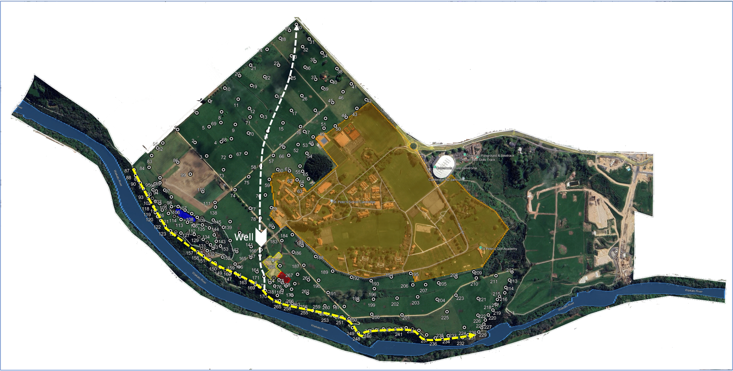
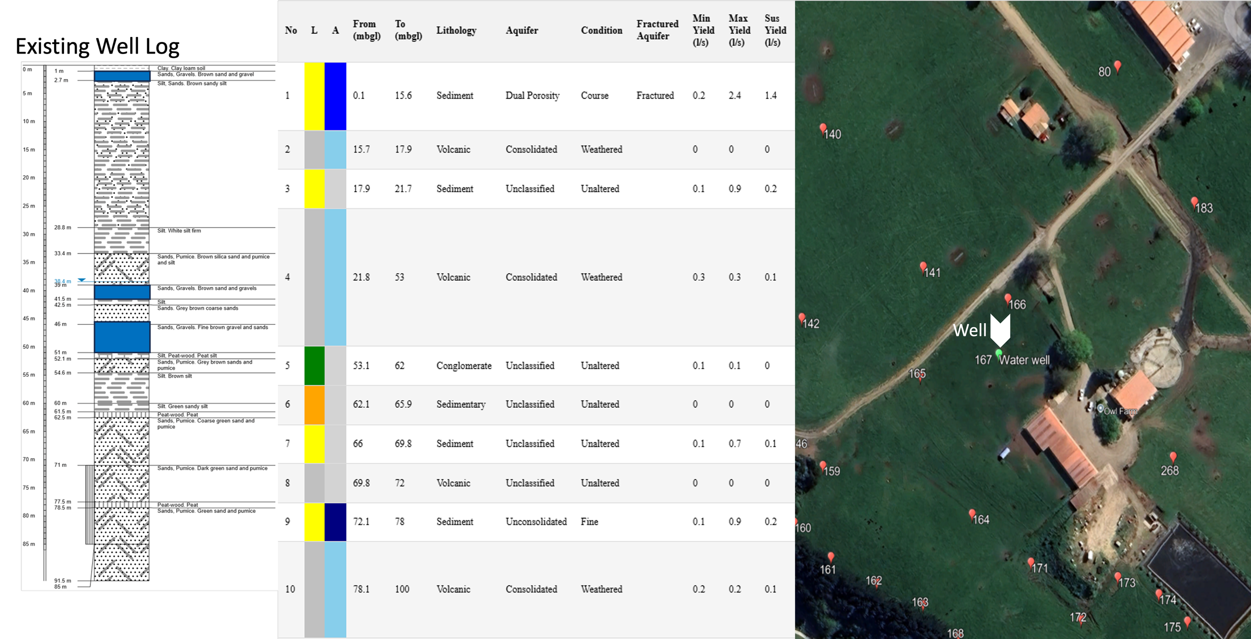
The site has an existing well, located at Point 167, which has a lithological log to a depth of 92 meters. This well log is used to compare the collected geophysical datasets against, in order to validate the accuracy of the site data at at least one location. The comparative analysis between the existing well lithological log and the geophysical virtual log indicated correlation between the estimated and actual formation geology and hydrogeology, providing validation to the geophysical data. The depth estimates for the virtual log lithological interfaces appear to closely match the well log, indicating that the site velocity models are reasonably accurate.
Soil Hydraulic Conductivity
Paleo Channel Mapping
As the survey was conducted in a 3D grid layout, the site data can be evaluated as a 3D profile, a 3D isometric model, or as 2D section cuts. Here we see the site's aquifer probability data, on the left plot as 3D profiles cutting across the site and running along the river. The data shows shallow surface aquifers about 10 meters deep, followed by a deeper aquifer about 20 to 30 meters deep. The 3D isometric model of the aquifer probability to the right, shows that both the shallow and deeper aquifers extend across the site.
Wetland Investigations
Aquifers
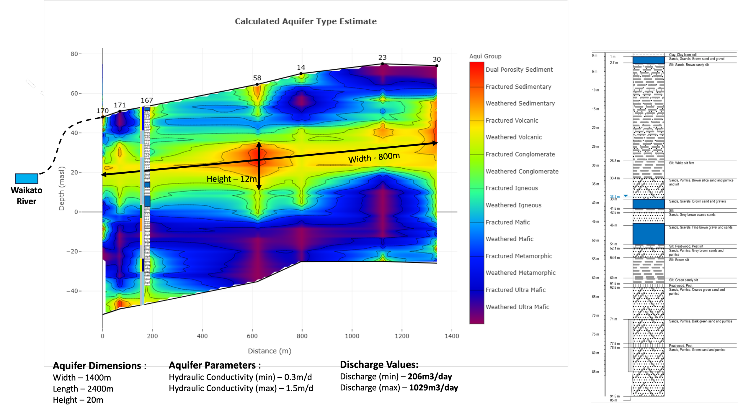
The site's aquifer classification data shown here for the white transect line shown on the survey layout, indicates a shallow aquifer extending from surface level to approximately 5 meters below surface level, and a deeper aquifer at approximately 20 meters above sea level. Both aquifers are indicated to be dual porosity gravel aquifers, which is confirmed by the well log. The shallow aquifer appears to be disjointed and inconsistently distributed across the site, however, the deeper aquifer appears to extend across the entire site. As the deeper aquifer lays at a depth equivalent to the elevation of the adjacent Waikato River, it is likely that there is groundwater surface water interaction between this aquifer and the Waikato River. Assuming a direct connection between the river and aquifer with no isolating formations or clay beds between them, we can use Darcy’s Law to calculate the discharge flow rate of groundwater into the river. This is done using an aquifer height of 20 meters, width of 1400 meters and length of 2400 meters along the Waikato River. The hydraulic conductivity data for the aquifer indicates a minimum value of 0.3 meters per day and a maximum value of 1.5 meters per day, resulting in a calculated discharge rate range of 206 to 1029 cubic meters per day.
An investigation of the aquifer at the gravel bed depth of 25 meters above sea level, indicates that the aquifer may be a part of a paleo channel formation, located in the southeast to northwest direction. There are also indications that a secondary paleo channel flow path may also be connected perpendicularly to the main aquifer.
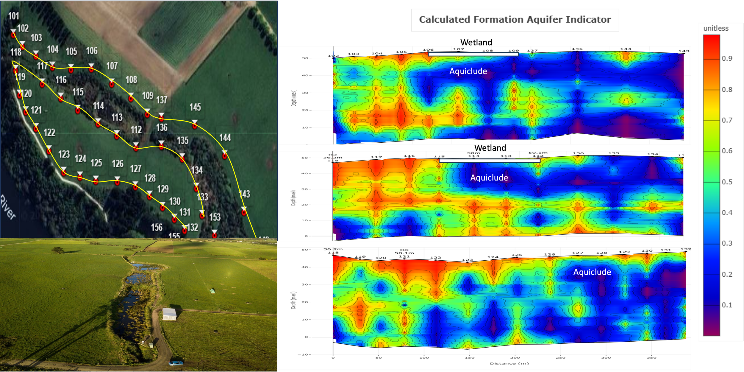
A small wetland exists on the survey site. A study as to the groundwater surface water interaction was conducted around the wetland. This was investigated using three profile lines to the north and south of the wetland and one that runs along the river to the south of the wetland. The data indicates that the majority of the wetland lies above an aquiclude formation, preventing drainage of the wetland waters into the underlying aquifer. There is some higher permeability material at the surface to the west of the wetland, which may allow some drainage. It is interesting that the wetland aquiclude does not extend to the river, indicating that it is a localized geological feature.
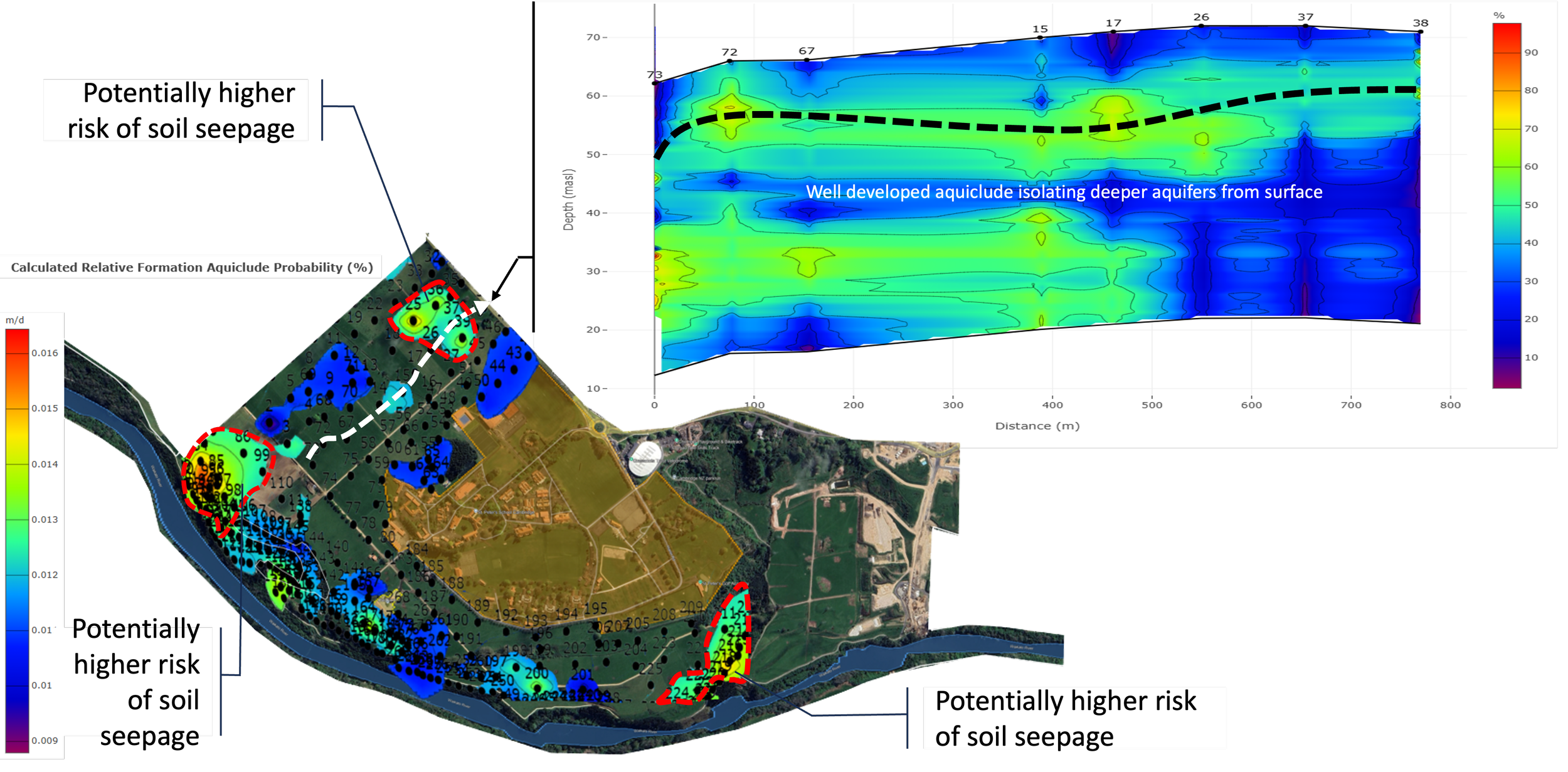
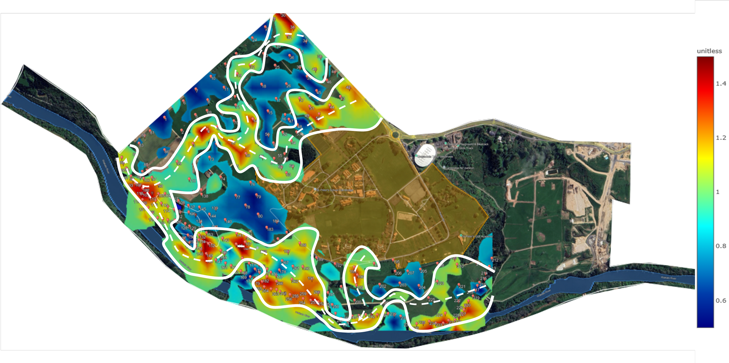
Effluent fertilization is used on the northwestern fields of the site to promote grass growth. When using fertilizers, seepage into deeper aquifers may be of concern in order to maintain water quality within the aquifers. One method of mitigating risk of seepage is to identify areas on a site where soil hydraulic conductivity may be higher, and reducing or monitoring the amounts of fertilization in these areas. This map shows where the hydraulic conductivity of the farm’s soils are higher and may need additional monitoring. In the case of this study, the soil hydraulic conductivity is very low at only 16 millimeters per day at it highest, so seepage should not be a concern. However, the variations in hydraulic conductivity can clearly be seen and identified as higher risk areas. To investigate the potential seepage or leaching risk of nitrates that made it through the upper soil formations into deeper aquifers, analysis of the site's northwestern pasture aquiclude formations was conducted. The data shows a well-developed aquiclude extending across the upper pasture, which effectively isolates the lower aquifers from the upper aquifer, reducing risk of nitrate leaching into the deeper formations.