Environmental Management
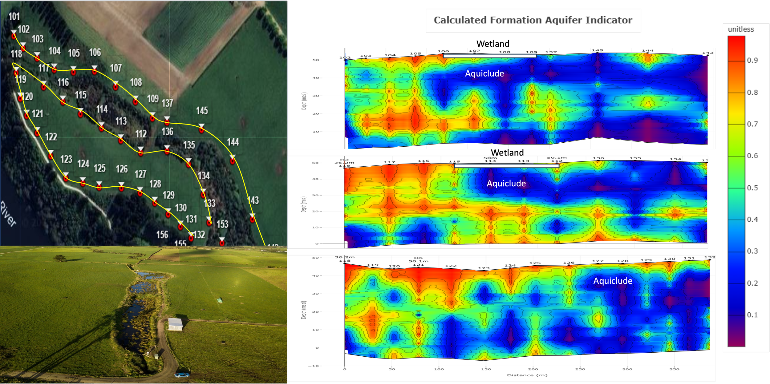
Wetland Studies
A small wetland exists on this survey site. A study as to the groundwater surface water interaction was conducted around the wetland. This was investigated using three profile lines to the north and south of the wetland and one that runs along the river to the south of the wetland. The data indicates that the majority of the wetland lies above an aquiclude formation, preventing drainage of the wetland waters into the underlying aquifer. There is some higher permeability material at the surface to the west of the wetland, which may allow some drainage. It is interesting that the wetland aquiclude does not extend to the river, indicating that it is a localized geological feature.
Effluent Management
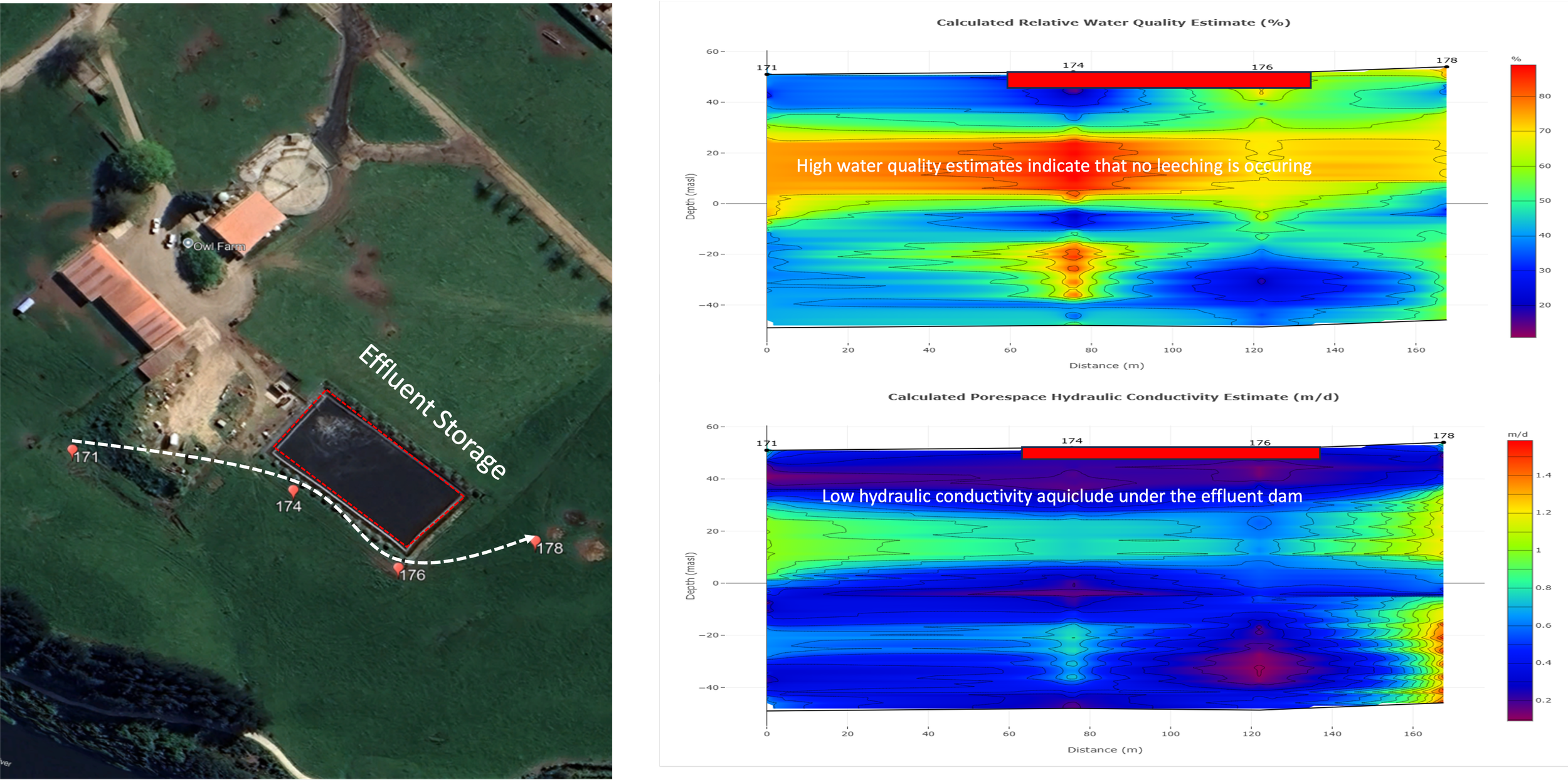
There is an effluent management center on this site, which includes an effluent processing dam. An analysis of the dam indicates that it lays above a low hydraulic conductivity formation that isolates the dam from the underlying aquifer at a depth of 30 meters below surface level. An analysis of the aquifer water quality indicates a high water quality level, which is indicative that no leaching of effluent is occurring.
NAPL Contamination Plume
Here we see an example of how the GeoView system can be used to delineate the contamination plume created by a non-aqueous phase liquid spill. On this site, a leaking storage facility contaminated a shallow sedimentary aquifer system with non-aqueous phase liquid. An investigation of the site showed that a contamination plume had developed in the direction of the natural groundwater flow gradient of the site, as expected. However, a wider investigation of the area showed non-aqueous phase liquid indicators in unexpected locations around the contamination site that were not coupled to the site natural groundwater flow path. To provide insight into the nature of the flow paths taken by the contamination plume, the GeoView system was used.
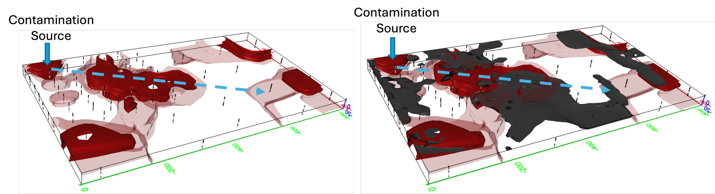
The data collected shows the main contamination plume was in fact developing in the direction of the groundwater gradient, and the outlined contamination areas are also shown. When fracturing data is overlaying on the contamination data, it can be seen that fracturing in the volcanic formations directly beneath the sedimentary aquifer is providing a high permeability flow path for the non-aqueous phase liquid to migrate to distant areas of the site, not specifically coupled to the natural groundwater flow direction.
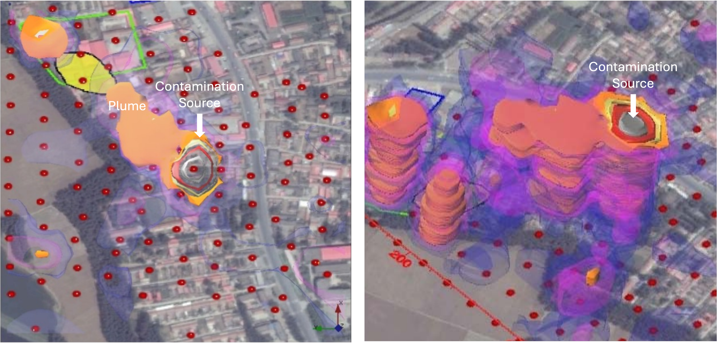
Here we see an example of an LNAPL contamination investigation using the GeoView system. In this study, coupling efficiency data was used to delineate the extent of the spread of the contamination plume. The contamination plume development can clearly be seen on the provided plots. This allowed the client to develop effective remediation strategies.
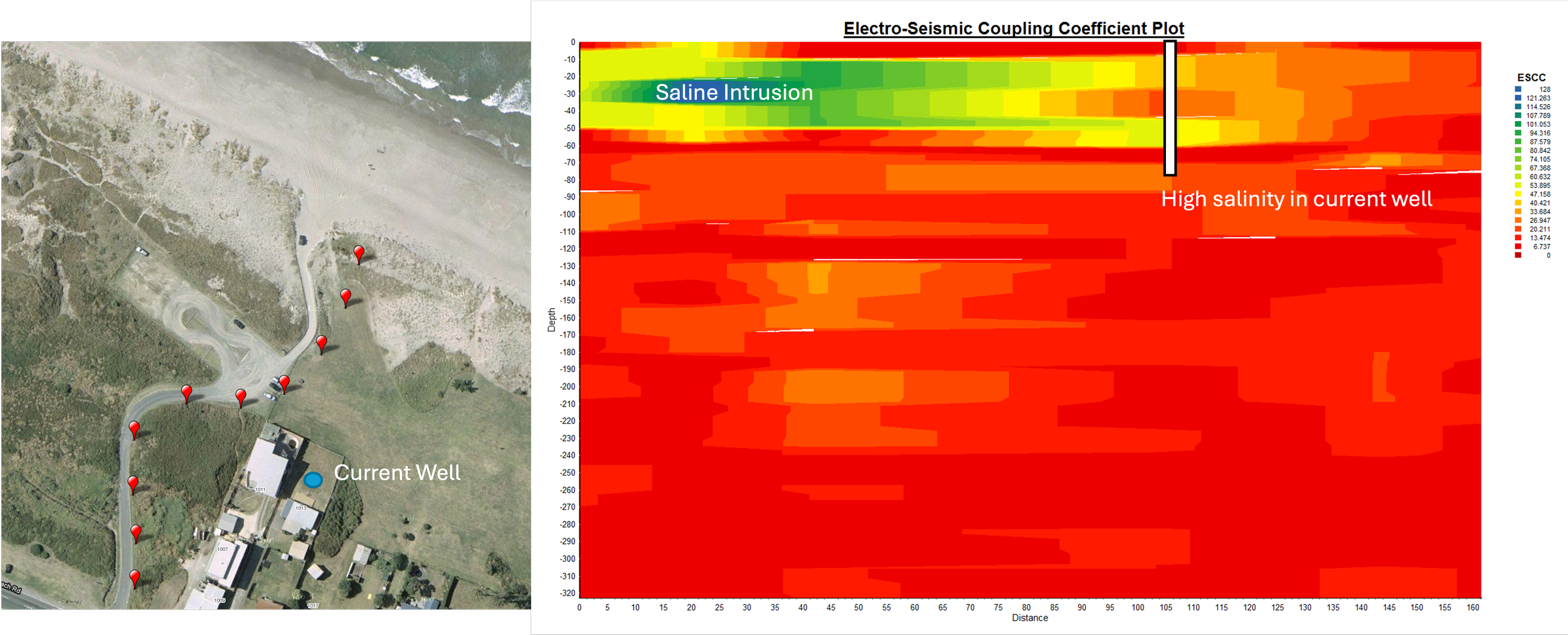
Saline Intrusion
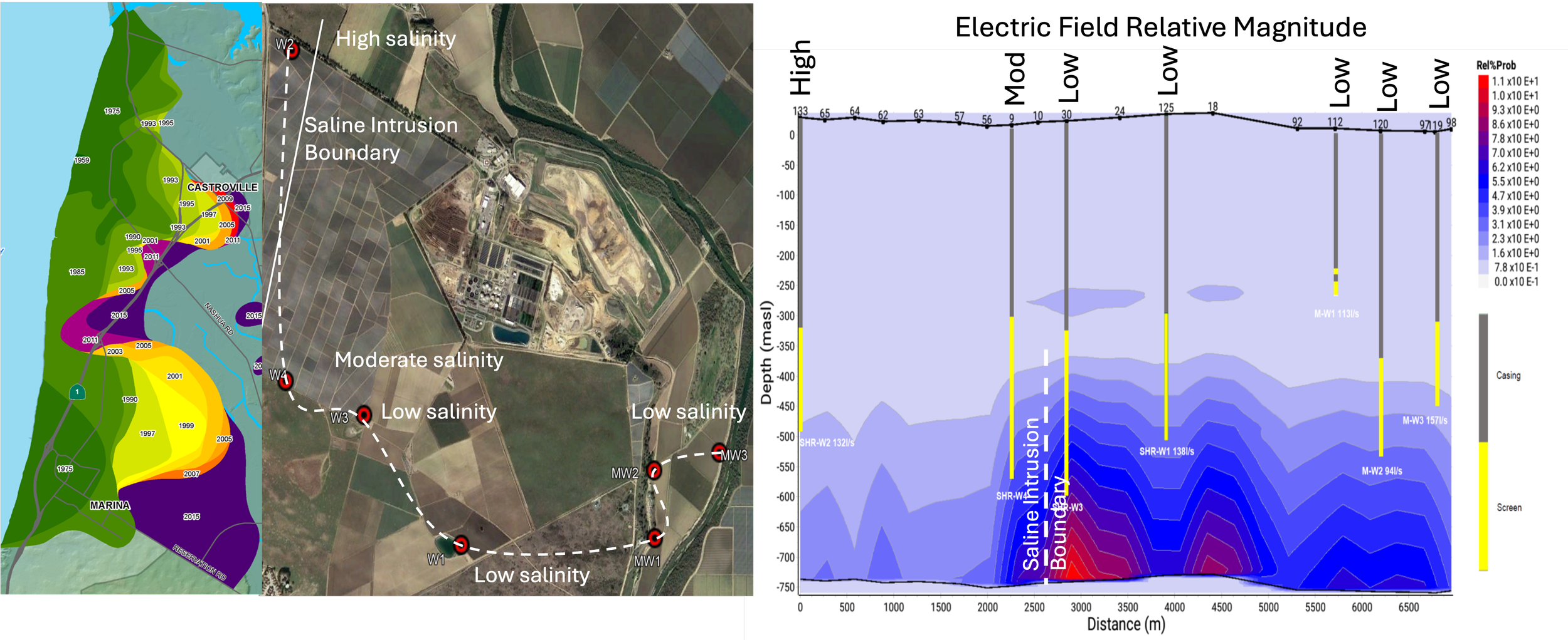
This site, located in California, showed indications of saline intrusion within its deep underlying aquifer systems used for major irrigation purposes. Studies of the area concluded that high levels of groundwater extraction were the cause of saline intrusion from the ocean 500 yards to the west. GeoView conducted a study to investigate the boundaries of the saline intrusion ingress into the deep aquifer systems under the investigation site in order to provide the client with the information required to mitigate the problem. The site has seven wells drilled into the deep aquifers of concern, two of which showed indications of saline intrusion to the west of the site. The remaining wells to the east did not indicate any saline intrusion. An electric field magnitude investigation was employed to investigate the site and delineate the saline intrusion boundary. To accomplish this, a profile of points were surveyed between the current wells on the site. The data shows that the two wells to the far west of the investigation area showed the lowest relative electric field magnitude, indicating that the boundary of the saline intrusion ingress was limited to the western side of the investigation area, parallel with the coastline. The data provided allowed the client to accurately model more effective water extraction methods to slow the saline intrusion ingress.
This study was conducted for Environment Bay of Plenty in New Zealand to determine the extent of saline intrusion into the shallow aquifers under the investigation site due to groundwater extraction near the ocean. The data clearly shows that the current well operating on the site is drawing in saline water into the shallow aquifer system, thus contaminating the site as far inland as the well location.